
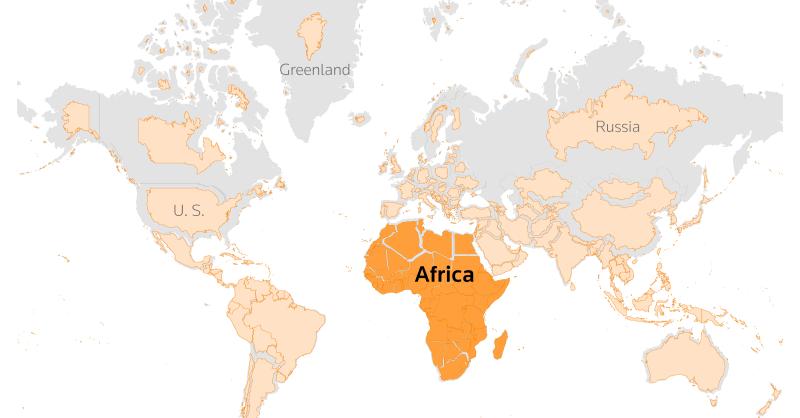
The United Nations General Assembly has backed a new world map designed to give a more accurate picture of the actual size of continents, making Africa appear significantly larger than it does on the traditional map.
The resolution, led by several African countries, secured the support of 164 member states during Friday’s vote. The United States opposed the proposal, while six countries abstained.
The new map uses the Equal Earth projection, which presents continents according to their relative surface areas. The resolution describes it as a suitable option for improving the accuracy of global cartographic representation.
The UN has urged member states to consider adopting the projection instead of the widely used Mercator map.
The Mercator projection dates back to 1569, when Flemish cartographer Gerardus Mercator developed it mainly to assist maritime navigation. Although it accurately represents directions and shapes in many areas, it distorts the relative size of land masses.
That distortion makes regions closer to the poles appear much larger than they actually are. As a result, Europe and North America look considerably bigger, while Africa and South America appear smaller.
Foreign Minister Robert Dussey of Togo, which spearheaded the initiative, said maps influence how people understand the world.
“Maps guide education, nourish the imagination, and influence collective perceptions,” Dussey said.
He added that distorted maps could reinforce inaccurate ideas about the size and importance of different parts of the world.
Cartographers developed the Equal Earth projection in 2018 to address some of those distortions. The map gives Africa, Latin America, South Asia and Oceania a much larger visual presence.
One of its creators, Bojan Savric, said the projection preserves the relative surface areas of continents while keeping their shapes as close as possible to their appearance on a globe.
France, which co-sponsored the resolution, also announced plans to move away from the Mercator projection.
French Foreign Minister Jean-Noel Barrot argued that the traditional map gives countries such as the United States, Russia and China disproportionate visual prominence compared with Africa, Latin America and Southeast Asia.
He also pointed to Greenland, which appears almost as large as Africa on the Mercator map despite being far smaller in actual land area.
“Changing maps obviously doesn’t change the world,” Barrot said. “But correcting a distorted representation is already an act of truth.”
The United States, however, criticised the initiative and questioned the decision to devote UN attention to the issue.
US representative Yaryna Ferencevych argued that the organisation should focus on what Washington considers more pressing global challenges.
The move also carries diplomatic significance for France, which has been working to strengthen relations with African countries, particularly former colonies where tensions over its historical role remain.
📢 Follow National Periscope on WhatsApp
Get breaking news and updates directly on WhatsApp.
Join WhatsApp ChannelPost Disclaimer
All rights reserved. This material and other digital content on this website are not and do not represent the stance of National Periscope but the statements of newsmakers mentioned therein.
For your detailed news reportage... contact the Editor at Joel2oladele@gmail.com




Iran Rules Out Ceasefire as Trump Escalates Threats Over Strait Read more
Democrats accuse Republicans of falling for ‘Russian propaganda’ in Biden Read more
US sues tech giant Apple for "monopolising" smartphone market The Read more
US military launches another wave of missiles against Houthi-controlled sites Read more